Odisha Geography Probable MCQs with Explanations.

Which of the following physiographic divisions has the maximum spatial coverage in Odisha?
The Central Plateau Region
The Coastal Plains
The Middle Mountainous and Highland Region
The Western Rolling Uplands
Detailed Solution
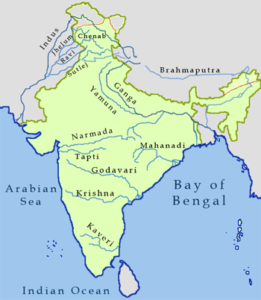
Odisha is located in the eastern part of the Indian peninsula and the Bay of Bengal lies to its East while Chhattisgarh shares its border in the west and north-west.
The state also shares geographic boundaries with West Bengal in the north-east, Jharkhand in the north, and Andhra Pradesh in the south.
Key Points
The Middle Mountains and Highland Regions:
It is the largest of the geographic regions and covers about three-fourths of the state.
Geologically the formation is quite old. It is a part of the Indian Peninsula which was a part of the ancient landmass of Gondwanaland.
The rivers of Odisha and their tributaries have cut deep and narrow valleys in this region. The Odisha highlands are also known as the Garhjat hills.
This region is well-marked by a number of watersheds. A number of river valleys of varying width and flood plains dissect the Eastern Ghats in this region.
The average height of this region is about 900 meters above the mean sea level. The highest peak is Deomali.
Hence, the correct answer is The middle mountains and Highland Regions.
Additional Information
Odisha can be divided into five major Physiographic regions:
Utkal plains or the coastal plains of the east: They are the sedimentary landforms of recent origin. A major part of this region is formed by deltas of the six major rivers i.e. the Mahanadi, the Brahmani, the Budhabalanga, the Subarnarekha, the Baitarani, and the Rushikulya.
The central plateaus: The plateaus are part of the western slopes of the Eastern Ghats. They have mostly eroded plateaus with elevations varying from 305 to 610 meters. There are two broad plateaus: (i) the Panposh-Keonjhar-Pallahara plateau comprises the Upper Baitarani catchment basin in the northern part of the state (ii) the Nabrangpur-Jeypore plateau comprises the Sabari basin in the southern part of the state.
The central mountainous and highlands region: The region mostly comprises the hills and mountains of the Eastern Ghats which rise sharply in the east and slope gradually to the eroded plateaus in the west running from the north-west to the south-west.
The western rolling uplands: The western rolling uplands have heights varying from 153 metres to 305 metres. These are lower in elevation than the plateaus
The main flood plains: These flood plains are formed due to major rivers in the highlands, uplands, and plateaus. The height varies from 75 to 153m.

2. The Odisha highlands are also known as the:
Garhjat Hills
Gali Konda
Turia Konda
Nilgiri Hills
The correct answer is Garhjat Hills.
Key Points
The Garhjat Hills is a mountain range formed by a series low lying hills, plateaux, ridges, and meadows that stretch into Odisha from the Utkal Plains in the Chotanagpur region of Jharkhand and the Chhattisgarh Plains.
The Garhjat hill is also known as Odisha Highland.
Middle Mountain and Highland Region are well marked by a number of interfluves or watersheds.
The Eastern Ghats is interrupted by a number of broad and narrow river valleys and flood plains.
The average height of this region is about 900 meters above the mean sea level.
The highest peak of Odisha is Deomali.
Additional Information
Galikonda is the second-highest mountain in the Eastern Ghats. It is 4320 ft above sea level. It lies on the route between Borra Caves and Araku Valley of Andhra Pradesh State.
Turia Konda is a mountain in Odisha and has an elevation of 1562 meters.
The Nilgiri Mountains form part of the Western Ghats in northwestern Tamil Nadu, Southern Karnataka, and eastern Kerala in India.
The highest peak of Eastern Ghats is the Jindhagada peak of Andhra Pradesh. It is also known as Arma Konda or Sitamma Konda.
3. Mahendragiri Hills are located in ______.
Himachal Pradesh
Tamil Nadu
Odisha
Maharashtra
The correct answer is Odisha.
Key Points
Mahendragiri is a mountain in Odisha, India, located in the Rayagada subdivision of the Gajapati district.
It is located at an elevation of 1,501 metres in the Eastern Ghats (4,925 ft).
After Deomali in the Koraput district, this is Odisha's second-highest mountain peak. It has some fascinating ancient relics.
Because of the various medicinal plants and other species present here, Mahendragiri hill and its surrounding areas have been designated as a biodiversity hotspot.
Mahendragiri Hills, part of the Eastern Ghats, is home to over 600 flowering plants and is a refuge for medicinal plants.
In 1986, the Ministry of Environment and Forests of the Government of India requested to the State Government of Odisha that the Mahendragiri hill be designated as a Biodiversity Hotspot location.
The Forest and Environment Department's expert group has also suggested that the bio-diversity hotspot Mahendragiri Hills be designated as a Biosphere Reserve in 2014.
4. Which of the following is a landlocked District in the state of Odisha?
Bhadrak
Puri
Mayurbhanj
Baleswa
Correct Answer is Mayurbhanj.
Key Points
Mayurbhanj was a princely state until its merger with the state of Odisha . Mayurbhanj got merged into the state of Odisha on 1st January 1949. Since it became one of the District Of Odisha.
It is a landlocked district and is situated on the Northern boundary of the state. It is bounded in the North-East by the Midnapore district of West Bengal, North-west by the Singhbhum district of Jharkhand in the South-east Balasore and by kendujhar in the South-West. It is the largest district of Odisha by area of 10,418 sq Km
Simlipal National Park is a national park and a tiger reserve in the Mayurbhanj district. Additional Information
Bhadrak district came into existence on 1st April 1993. This is bounded by Balasore district on the North, Jajpur district and River Baitarani on the South, Keonjhar District on the West, and Bay of Bengal and Kendrapara District on the East.
Puri is a Coastal District of Odisha. The district is bounded by Bhubaneswar on the North, Chilika Lake on the south and the Bay of Bengal on the East.
Baleswar is one of the coastal districts of Odisha. It lies in the Northern part of the state. The land was filled with sand and hence it was known as Baleshwar, the city of Sand.
5. By which of the following two rivers is the northern part of the Eastern Ghats bifurcated?
The Subarnarekha and The Baitarani
The Baitarani and The Brahmiani
The Brahmani and The Mahanadi
The Rushikulya and The Vanshadhara
Detailed Solution
The coastal plains of Orissa stretch on the eastern coast of India from the Subarnarekha in the north-east to the Rushikulya in the south-west.
This fertile region is known as the 'rice bowl' of Orissa.
The coastal plain is a gift of six major rivers.
The formation of the coastal plains depends on the rivers and their catchment area.
The rivers are: From north to the south, the Subarnarekha, the Burhabalanga, the Baitarani, the Brahmani, the Mahanadi, and the Rushikulya.
Key Points
According to the location, the coastal plain can be divided into three sub-regions:
a) The north coastal plains - the deltas of the Subarnarekha and the Burhabalanga up to the river Baitarani
b) The middle coastal plains - the combined deltas of the Baitarani, the Brahmani, and Mahanadi
c) The southern coastal plains - the Rukshikulya plains can be divided into three zones parallel to the shoreline.
Hence, the correct answer is the Subarnarekha and the Baitarani.
Additional Information
Subarnarekha: The Subarnarekha originates from the Ranchi Plateau in Jharkhand forming the boundary between West Bengal and Odisha in its lower course.
Brahmani: The basin is bounded in the North by Chhotanagpur plateau, in the West and South by the Mahanadi basin, and in the East by the Bay of Bengal. The basin flows through Jharkhand, Chhattisgarh, and the Orissa States and drains into the Bay of Bengal.
Baitarani: A major portion of the river basin lies within the state of Odisha, while a small patch of the upper reach lies in Jharkhand state. The upper Baitarani basin on the western slopes of the Eastern Ghats, comprising the Panposh-Keonjhar-Pallahara plateau, is one of the two plateaus forming "The Central Plateaus"—one of Odisha's five major morphological regions.
Mahanadi: The river Mahanadi originates at an elevation of about 422 mts. above mean sea level near Pharsiya village near Nagri town in Raipur district of Chhattisgarh. It is one of the major inter-state east-flowing rivers.
Rashikulya: the Rushikulya River is one of the major rivers in the state of Odisha and covers the entire catchment area in the districts of Kandhamal and Ganjam of Odisha.
Vanshadhara: The river originates in the border of Thuamul Rampur in the Kalahandi district and Kalyansinghpur in the Rayagada district of Odisha and runs for a distance of about 254 kilometers, where it joins the Bay of Bengal at Kalingapatnam, Andhra Pradesh.
6. In which of the following states, the Garhjat Mountains are mainly spread?
Rajasthan
Gujarat
Odisha
Madhya Pradesh
The correct answer is Odisha.
Key Points
The Garhjat Hills is a mountain range formed by a series of low-lying hills, plateaux, ridges, and meadows that stretch into Odisha from the Utkal Plains in the Chotanagpur region of Jharkhand and the Chhattisgarh Plains.
The range, also known as the Odisha Highlands, runs in a northeast to a southwest direction for about 382 km along the Odisha coast, covering 76,800 km2.
Malayagiri is the highest peak of Garhjat Hills.
Additional Information
State- mountain Renj -Highest Peak
Rajasthan- Aravali- Guru Shikhar (1722m)
Gujarat -Gorakhnath- Girnar (1,110m)
Madhya Pradesh -Mahadeo Hills- Dhoopgarh (1,352m)
7. In the scheme of the physiographic division of India by S. P. Chatterjee in which sub-division of the Peninsular Plateau the Mahanadi Basin is included?
The Northern Deccan Plateau
The Southern Deccan Plateau
The Eastern Plateau
The Eastern Ghats
The correct answer is The Eastern Plateau
Key Points
S. P. Chatterjee included the Peninsular Plateau of the Mahanadi Basin in the physiographic division of India.
India can be divided into six geographic regions. They are
The Himalayan region
The Northern Plains,
The Thar Desert,
The Peninsular Plateau,
The Malabar Coast, and
The Nilgiri.
The Peninsular region of India is very rich in both metallic as well as for non-metallic minerals.
Additional Information
The Peninsular Plateau of India consists of narrow coastal plains of varied width from north to south, known as the West Coastal Plains and the East Coastal Plains.
Mahanadi basin is also known as the Chhattisgarh Plain. It is spread over the districts of Raipur, Bilaspur, Durg, and Rajgarh.
Prof. S.P. Chatterjee (1973) also divided the Himalayas into six transverse divisions. These divisions are as follows:
Kashmir Himalayas
Himachal Himalayas
Kumaun Himalayas
Sikkim Himalayas
Arunachal Himalayas
Purvanchal Himalayas
8. Which is the smallest district in Odisha in terms of area?
Nayagarh
Dhenkanal
Jagatsinghpur
Boudh
The correct answer is Jagatsinghpur.
Key Points
Jagatsinghpur district is surrounded by the Bay of Bengal in the East, Cuttack district in the West, Kendrapada district in the North, and Puri district in the South.
Geographical area of 1759 sq km, the Jagatsinghpur district is the smallest district in Odisha in terms of territorial location.
This district has got a total population of 11,36,971 including 577,865 males and 559,106 females as per the 2011 census.
The average literacy rate of the district is 79.08 percent comprising 88.55 percent male literacy rate and 69.28 percent female literacy rate.
Jagatsinghpur District has only one subdivision namely Jagatsinghpur.
Jagatsinghpur District enjoys a temperate climate.
Winters are cold, while summers are hot and humid. The District is prone to cyclonic rainfalls during the monsoons.
The District is packed with many attractive places such as Paradeep Port, Paradeep, Paradeep Garh, Sarala Temple-Jhankad and Garh Kujanga are some of the visiting places of the District.
Gorakhanath Temple is one of the most attractive temples in the District. Jagannath Temple of Garoi is also a famous tourist spot visited by a large number of people from around the world.
The Major food crop grown in Jagatsinghpur District is paddy. Sugarcane, turmeric, and cotton are the major commercial crops.
The District enjoys the rich fertile soil of the Mahanadi.
9. Daringbadi, popularly known as Kashmir of Odisha is located in which of the following districts of Odisha?
Puri
Sambalpur
Bhadrak
Kandhamal
The correct answer is Kandhamal.
Key Points
Daringbadi hill station is located in the Indian state of Odisha. Daringbadi Hill is Kandhamal district of Odisha state in eastern India.
It is situated at a height of 3000 ft. The temperature level of Daringbadi has often been recorded below 0 °C. It is also famous for ginger harvesting.
Additional Information
It is widely known as the "Kashmir of Odisha". It is situated at a height of 915 meters and is a popular tourist destination.
The place is gifted with natural bounties such as pine jungles, coffee gardens, and beautiful valleys. It is the only place in Odisha that experiences snowfall during winter.
The Rushikulya River originates at an elevation of about 1000 meters from the Daringbadi hills of the Eastern Ghats range.
10. In which part of India is the Dandakaranya situated?
Northern
East
Central
Western
The correct answer East.
Key Points
Dandakaranya, a physiographic region in east-central India. It includes the Abujhmar Hills in the west and borders the Eastern Ghats in the east.
The Dandakaranya includes parts of Chhattisgarh, Odisha, Telangana, and Andhra Pradesh states.
It spans about 300 kilometres (200 mi) from north to south and about 500 kilometres (300 mi) from east to west.
The Balaghat district of Madhya Pradesh and Bhandara, Gondia, and Gadchiroli districts of Maharashtra are part of the ancient region Dandakaranya.
Dandakaranya is a historical region in India, mentioned in the Ramayana.

11. Deomali is the highest mountain peak of which state?
Odisha
Andhra pradesh
West Bengal
Tamil Nadu
The correct answer is option 1, i.e. Odisha.
The Deomali (1672m) mountain peak is situated on the Eastern Ghat in Odisha. It is the highest peak of Odisha.
It is located in the Koraput district of Odisha.
The Sandakphu is the highest peak of West Bengal.
The Doddabetta is the highest peak of Tamilnadu.
12. Which of the following is the largest river of Odisha?
Godavari
Tapi
Krishna
Mahanadi
The correct answer is Mahanadi.
Mahanadi is the major river of Odisha and the 6th largest river in India.
It is believed that it originates from the Sihawa hills of the Bastar Plateau in the Raipur district of Chhattisgarh.
Key Points
It has a length of 851 kilometers of which 494 kilometer flows in Odisha. 42% of the catchment area lies in Odisha.
The tributaries of Mahanadi are the Tel river, Ib river, and Ong river.
The tributaries of Mahanadi in Chhattisgarh are the Seonath, the Hasdeo, the Jonk, and the Mand.
13. Which one of the major rivers of Odisha does not have delta at its mouth ?
A. The Mahanadi
B. The Brahmani
C. The Rushikulya
D. The Baitarani
The correct answer is The Rushikulya.
Key Points
The Rushikulya River is one of the major rivers in the state of Odisha. It covers the entire catchment area in the districts of Kandhamal and Ganjam district of Odisha.
The Rushikulya originates at an elevation of about 1000 metres from the Daringbadi hills of the Eastern Ghats range.
The place from where the river originates, Daringbadi is called the ‘ Kashmir of Odisha.‘
It meets the Bay of Bengal at Puruna Bandha in Ganjam. Its tributaries are the Bagua, the Dhanei, the Badanadi etc. It has no delta as such at its mouth.
Additional Information
The Mahanadi

The Mahanadi river system is the third-largest river system in peninsular India. It is about 860 km long. It is the largest river in Odisha state.
The word Mahanadi is made of the Sanskrit words Maha which mean great and Nadi which means river.
The river is bounded by the Central India hills on the north, by the Eastern Ghats on the south and east, and by the Maikala range on the west.
The river originates in the northern foothills of Dandakaranya, Raipur District of Chhattisgarh. It rises in the highlands of Chhattisgarh.
The river is one of the major rivers of the peninsular rivers, in water potential and flood-producing capacity. Hence, the river is also known as the Sorrow of Orissa.
The Mahanadi River flows through the states of Chhattisgarh and Odisha, Jharkhand, Maharashtra, and Madhya Pradesh. So, A part of its river basin lies in Maharashtra. It drains into the Bay of Bengal.
The Brahmani
It is a major seasonal river in the Odisha state of eastern India. Hence, statement 1 is correct.
The Brahmani river comes into existence by the confluence of the Koel and the Sankh rivers near Rourkela. Hence, statement 2 is correct.
The basin is bounded in the North by the Chhotanagpur plateau, in the West and South by the Mahanadi basin and in the East by the Bay of Bengal.
The basin flows through Jharkhand, Chhattisgarh and Orissa States and drains into the Bay of Bengal. Hence, statement 3 is correct.
The Talcher-Angul coal mines, steel and power plants as well as the Kalinganagar steel and power hub are drawing enormous quantities of freshwater from the Brahmani river
Bhitarkanika a notified Ramsar wetland is spread over 195 sq. km and is home to 62 mangrove species.
Proportionate freshwater flow from the Brahmani river basin and the Kharasrota river keep the salinity level of the water along the shore down.
The Baitarani
The Baitarani river originates from the hill ranges of the Keonjhar district of Odisha.
It is an east-flowing river of peninsular India, flowing eastward and joining the Bay of Bengal.
Major portion of its catchment lies in the state of Odisha and a small patch of the upper reach falls in Jharkhand.
The border dispute between Odisha and Jharkhand arises due to change in course of river Baitarani.
14. Consider the following rivers :
1. Brahmani 2. Nagavali 3. Subarnarekha 4. Vamsadhara
Which of the above rise from the Eastern Ghats?
1 and 2
2 and 4
3 and 4
1 and 3
The correct answer is 2 and 4.
Key Points
Brahmani:
The Brahmani is a major seasonal river in the Odisha state of eastern India. The Brahmani is formed by the confluence of the Sankh and South Koel rivers near Rourkela. Hence, 1 is not correct.
Together with the river Baitarani, it forms a large delta before emptying into the Bay of Bengal at Dhamra.
Nagavali:
The River Nagavali is also known as Langulya is one of the main rivers of Southern Odisha and Northern Andhra Pradesh States in India, between Rushikulya and Godavari basins.
Nagavali River originates in Kalahandi District, in eastern Ghats. Hence, 2 is correct.
Subarnarekha:
The Subarnarekha originates from the Ranchi Plateau in Jharkhand forming the boundary between West Bengal and Odisha in its lower course. Hence, 3 is not correct.
It joins the Bay of Bengal forming an estuary between the Ganga and Mahanadi deltas. Its total length is 395 km.
Vamsadhara:
It is an east-flowing river that originates in the Kalahandi district of Odisha, Eastern Ghat, flows in Odisha, along its boundary with Andhra Pradesh and finally joins the Bay of Bengal at Kalingapatnam, Andhra Pradesh. Hence, 4 is correct.
It is the main river of the north-eastern Andhra region and the Boddepalli Rajagopala Rao Project was constructed on it to meet the irrigation needs of the region.
15. Which of the following river basin is present in Odisha?
Narmada
Mahanadi
Krishna
Kaveri
The correct answer is Mahanadi.
Key Points
Mahanadi
The river basin present in Odisha is Mahanadi. In East-Central India, the Mahanadi River is an important river. It has a length of 900 kilometres overall and drains an area of around 132,100 square kilometres.
Mahanadi is also home to the Hirakud Dam. Before joining the Bay of Bengal, the Mahanadi River travels through the states of Odisha and Chhattisgarh. Like many other seasonal Indian rivers, the Mahanadi originates from the confluence of many Himalayan streams, making it difficult to pinpoint its exact source.
Additional Information
Narmada
The Narmada River, also known as the Reva and formerly as Narbada or Nerbudda in English, is the fifth-longest river in India and the longest west-flowing river altogether.
It is also the state of Madhya Pradesh's greatest flowing river. This river traverses the Indian states of Gujarat and Madhya Pradesh.
Krishna
After the Ganges and the Godavari, the Krishna River is a river in the Deccan plateau and is the third-longest river in India.
In terms of water inputs and river basin area, it ranks fourth in India, behind the Ganges, Indus, and Godavari.
Kaveri
One of the largest rivers in India, the Kaveri flows through the states of Karnataka and Tamil Nadu.
The Kaveri River originates at Talakaveri in the Brahmagiri range in the Western Ghats, Kodagu district of the state of Karnataka, at an elevation of 1,341 metres above mean sea level.
It then flows for about 800 kilometres until emptying into the Bay of Bengal.
16. The city of Sambalpur is situated on the banks of the which river?
Indravati
Mahanadi
Kolab
Nagavali
The Correct Answer is Mahanadi.
Key Points:
Cuttack is located on the bank of the river Mahanadi.

The Origin of Mahanadi is from RAIPUR CHHATTISGARH
Mahanadi River is a river in central India, rising in the hills of southeastern Chhattisgarh state.
It has a total course of 858 kilometers (533 mi). The river originates from Sihawa Mountain in Chhattisgarh.
The river flows through the states of Chhattisgarh, Madhya Pradesh, and Odisha.
The largest dam, the Hirakud Dam is built on the river.
The principal tributaries of the Mahanadi river are; Sheonath, Jonk, Hasdeo, Mand, Ib, Ong, Tel
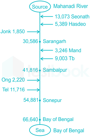
Additional Information
The Mahanadi basin extends over an area of 141,589 km2 which is nearly 4.3% of the total geographical area of the country.
The Mahanadi river ranks second to the Godavari river among the peninsular rivers in respect of water potential.
It lies between east longitudes 80° 30' to 86° 50' and north latitudes 19° 21' to 23° 35'.

17. Which of the rivers does NOT pass through Odisha?
Mahanadi
Brahmani
Godavari
Krishna
The Correct answer is 4. i.e. River Krishna does not pass through Odisha. Krishna
Krishna River Basin states are: Maharashtra, Telangana, Andhra Pradesh, Karnataka.
Krishna River is 1300 Kilometers long. It is the fourth largest river in India.
It originates in the Western Ghats near Mahabaleshwar at an elevation of about 1,300 metres, in the state of Maharashtra in central India
Two dams, Srisailam and Nagarjuna Sagar are constructed across the Krishna River.
Nagarjuna Sagar Dam is world’s tallest masonry dam (124 meters) on this river. Mahabaleswar, Amravati and Vijaywada are major cities.
Godavari
States Covered by River Godavari - Maharashtra, Telangana, Andhra Pradesh, Karnataka, Chhattisgarh, Madhya Pradesh and Odisha.
River Godavari is India’s second-largest river of India and also the longest river in South India.
It has a length of 1465 Kilometers. It originates near Trimbak in Nashik District of Maharashtra state and flows east across the Deccan Plateau into the Bay of Bengal near Narasapuram in West Godavari district of Andhra Pradesh.
The river is also known as Dakshin Ganga and Gautami.
Major cities across river Godavari-Trimbakeshwar, Nashik, Kopargaon, Paithan, Nanded, Rajahmundry, Adilabad and Bhadrachalam.
Havelock bridge is on Godavari River Polavaram multipurpose project on the Godavari River.
Mahanadi
The river flows through the states of Chhattisgarh and Odisha. Originates near hills of the Dhamtari district of Chhattisgarh.
The total course of 858 kilometres. The major tributaries of Mahanadi are Seonath, Jonk, Hasdo, Mand, Ib, Ong, Tel etc.
Brahmani
The Brahmani is formed by the confluence of the Sankh and South Koel rivers and flows through the districts of Sundargarh, Deogarh, Angul, Dhenkanal, Cuttack, Jajapur and Kendrapara in Odisha.
Together with the river Baitarani, it forms a large delta before emptying into the Bay of Bengal at Dhamra.
18. Which of the following rivers is also known as "Sorrow of Odisha"?
Damodar
Godavari
Mahanadi
Rushikulya
Detailed Solution
Mahanadi river is termed as the "Sorrow of Odisha".
It has been given this name for causing devastating floods.
Damodar river - "Sorrow of Bengal" Godavari river - "Vridha Ganga" or "Dakshina Ganga"
Rushikulya is a major river of Odisha which originates from Daringbadi hills of the Eastern Ghats range.
19. Which of the following statements about the Mahanadi river is INCORRECT ?
It rises in the highlands of Chhattisgarh.
It drains into the Arabian Sea.
A part of its river basin lies in Maharashtra.
It is about 860 km long.
The correct answer is It drains into the Arabian Sea.
Key Points
The Mahanadi river system is the third-largest river system in peninsular India. It is about 860 km long. It is the largest river in Odisha state.
The word Mahanadi is made of the Sanskrit words Maha which mean great and Nadi which means river.
The river is bounded by the Central India hills on the north, by the Eastern Ghats on the south and east, and by the Maikala range on the west.
The river originates in the northern foothills of Dandakaranya, Raipur District of Chhattisgarh. It rises in the highlands of Chhattisgarh.
The river is one of the major rivers of the peninsular rivers, in water potential and flood-producing capacity. Hence, the river is also known as the Sorrow of Orissa.
The Mahanadi River flows through the states of Chhattisgarh and Odisha, Jharkhand, Maharashtra, and Madhya Pradesh.
So, A part of its river basin lies in Maharashtra. It drains into the Bay of Bengal. Hence option 2 is an incorrect statement.
Additional Information
Left bank Tributaries of the Mahanadi river are The Seonath, the Hasdeo, the Mand, and the Ib.
Right bank Tributaries of the Mahanadi river are The Ong, the Tel, and the Jonk.
Major projects on the Mahanadi River are The Hirakud Dam, The Gangrel Dam and The Dhudhwa Dam.
20. Which of the following rivers originates from the Gonasika hills?
Mahanadi
Budhabalanga
Subarnarekha
Baitarani
The correct answer is Baitarani.
Key Points:
River- Origin
Mahanadi - sihawa, Chhattisgarh
Budhabalanga - Similipal, Mayurbhanj Dist.
Subarnarekha - Chhota Nagpur Plateau, Jharkhand
Baitarani- Gonasika hills, Kendujhar Dist.
Additional Information
The Mahanadi river system:
The Mahanadi river system is the third-largest river system of peninsular India. It drains an area of around 141,600 square kilometers (54,700 sq mi) and has a total course of 858 kilometers (533 mi).
It is the largest river in Odisha state. The word Mahanadi is made of the Sanskrit words Maha which mean great and Nadi which means river.
The river is bounded by the Central India hills on the north, by the Eastern Ghats on the south and east, and by the Maikala range on the west.
The river originates in the northern foothills of Dandakaranya, Raipur District of Chhattisgarh.
The river is one of the major rivers of the peninsular rivers, in water potential and flood-producing capacity. Hence, the river is also known as the Sorrow of Orissa.
The Mahanadi River flows through the states of Chhattisgarh and Odisha, Jharkhand, Maharashtra, and Madhya Pradesh.
Left bank Tributaries of the Mahanadi river are The Seonath, the Hasdeo, the Mand, and the Ib.
Right bank Tributaries of the Mahanadi river are The Ong, the Tel, and the Jonk.
Major projects on the Mahanadi River are The Hirakud Dam, The Gangrel Dam, and The Dhudhwa Dam.

Subarnarekha
The Subarnarekha originates from the Ranchi Plateau in Jharkhand forming the boundary between West Bengal and Odisha in its lower course.
It joins the Bay of Bengal forming an estuary between the Ganga and Mahanadi deltas. Its total length is 395 km.

Devi:
The Devi River, also known as the Dubrajpur River, is a major river in the Indian state of Odisha.
The river flows through several districts, including Keonjhar, Kendujhar, and Jajpur, before joining the Bay of Bengal.
The Devi River is significant for the local communities as a water source and for its religious importance.
Brahmani:
The Brahmani River is another important river in the state of Odisha, India. It has its origin in the Keonjhar district near the village of Sulasara.
The river flows through the districts of Sundargarh, Deogarh, Anugul, and Kendrapara before merging with the Bay of Bengal.
The Brahmani River, along with its tributaries, is crucial for irrigation, hydroelectric power generation, and supporting the agriculture and industrial sectors in the region.
21. Which of the following is not an important river of Malwa plateau?
Chambal river
Mahanadi river
Ken river
Betwa river
The correct answer is Mahanadi river.
Key Points
River Mahanadi originates from Sihawa Mountain near a village in Raipur, Chhattisgarh.
The Mahanadi River system is the third largest in peninsular India after Godavari and Krishna, and the largest river in Odisha state. The Mahanadi (“Great River”) follows a total course of 560 miles (900 km) and has an estimated drainage area of 51,000 square miles (132,100 square km).
The catchment area of the river extends to Chhattisgarh, Madhya Pradesh, Odisha, Jharkhand, and Maharashtra.
Tributaries- Seonath, Hasdeo, Mand, and Ib join Mahanadi from the left whereas, Ong, Tel, and Jonk join it from the right.
At Sambalpur, the Hirakud Dam on the river (the longest dam in India) has formed a man-made lake 35 miles (55 km) long; the dam has several hydroelectric generators.
It enters the Odisha plains near Cuttack and enters the Bay of Bengal at False Point by several channels.
Additional Information
Malwa plateau
Indian plateau region known as the Malwa Plateau. It is bordered to the north by the Madhya Bharat Plateau and Bundelkhand Upland, to the east and south by the Vindhya Range, and to the west by the Gujarat Plains.
The plateau, which is of volcanic origin, spans southeast Rajasthan state and central Madhya Pradesh state.
The Sanskrit word malav is where the name Malwa comes from (part of the abode of Laksmi [goddess of wealth]).
The Maurya, Gupta, and Paramara empires alternately dominated the plateau; during this time, numerous Buddhist temples and monuments (such as the stupas at Sanchi), known for their architecture and sculpture, were also constructed.
In 1390 CE, the Muslims took control of the plateau, which then belonged to the Maratha empire.
It was given to the British in 1817. The Malwa Plateau has an elevation range of 500 to 600 metres (about 1,650 to 2,000 feet).
Sandstone hills and solitary mesas, as well as remnants of old lava flows, may be seen scattered throughout the plateau.
The Mahi River drains the western portion of the area, the Chambal River the middle, and the Betwa River and the headwaters of the Dhasan and Ken rivers the eastern portion.
Additionally, there are the Parbati, Sipra, Gambhir, and Choti Kali Sindh rivers, all of whose valleys are bordered by terraced hills.
Savanna-style vegetation is present, with sporadic teak and sal (Shorea robusta) woods.
22. Which of the following is not a tributary of Mahanadi?
Indravati
Shivnath
Hasdeo
Telen
The correct answer is Indravati.
Key Points
The Mahanadi river system is the third-largest river system in peninsular India. It is about 860 km long. It is the largest river in Odisha state.
The word Mahanadi is made of the Sanskrit words Maha which mean great and Nadi which means river.
The river is bounded by the Central India hills on the north, by the Eastern Ghats on the south and east, and by the Maikala range on the west.
The river originates in the northern foothills of Dandakaranya, Raipur District of Chhattisgarh. It rises in the highlands of Chhattisgarh.
The river is one of the major rivers of the peninsular rivers, in water potential and flood-producing capacity.
Hence, the river is also known as the Sorrow of Orissa. The Mahanadi River flows through the states of Chhattisgarh and Odisha, Jharkhand, Maharashtra, and Madhya Pradesh.
So, A part of its river basin lies in Maharashtra. It drains into the Bay of Bengal.
Additional Information
Godavari:
It originates from the Tribakeshwar in Nashik district of Maharashtra. It drains into the Bay of Bengal.
It flows through the states of Maharashtra, Odisha, Chhattisgarh, Telangana, Andhra Pradesh.
Tributaries:
Left bank: Banganga, Kadva, Shivana, Purna, Kadam, Pranahita, Indravati, Taliperu, Sabari, Dharna.
Right bank: Nasardi, Pravara, Sindphana, Manjira, Manair, Kinnerasani.
23. Hirakud dam is situated on which river?
Ganga
Chenab
Ravi
Mahanadi
The correct answer is Mahanadi.
The Hirakud Dam is constructed across the river Mahanadi. Hirakud Dam is close to Sambalpur city in Odisha.
Sambalpur is called the rice bowl of Odisha.
Key Points
It is one of the first major multipurpose river valley projects that started after India's independence. It began its operations in 1957. The total length of the Hirakud Dam is 25.79 km.

24. Which of the following is the left bank tributary of river Mahanadi?
Ong
Jonk
Tel
Mand
The correct answer is Mand.
Key Points
Mand River:
It is a tributary of the Mahanadi River.
Origin: Surguja district in Chhattisgarh Falls in Mahanadi River near Chandrapur, Chhattisgarh.
Total Length: 241 km.
Additional Information
Mahanadi River:
Mahanadi drainage system is the largest drainage system in Chhattisgarh.
Ancient name: Kankanandani It is mentioned as Nilotpala in Vayu Puran and Chitrotpala in Skand Puran.
It is named after the disciple of Kshrangi Rishi, Mahananda
Origin: Sihava mountain in Dhamtri, Chhattisgarh
Falls in Bay of Bengal near Cuttack(Odisha)
Total Length: 858 km In Chhattisgarh, it flows at a distance of 285 km. Cities on its bank: Rajim, Sirpur, Shivrinarayan, and Chandrapur.
25. Two important rivers - one with its source in Jharkhand (and known by a different name in Odisha), and another with its source in Odisha - merge at a place only a short distance from the coast of Bay of Bengal before flowing into the sea. This is an important site of wildlife and biodiversity and a protected area. Which one of the following could be this?
Bhitarkanika
Chandipur-on-sea
Gopalpur-on-sea
Simlipal
The correct answer is Bhitarkanika.
Key Points
Bhitarkanika National Park :
Spread in a vast area of 672 Kms Bhitarkanika Indian Wildlife Sanctuary Orissa is the 2nd largest Mangrove ecosystem of India.
Proximity to the Bay of Bengal makes the soil of the area enriched with salts, the vegetation, and the species of the sanctuary is comprised of those which are mainly found in the tropical and subtropical intertidal regions.
It is the breeding place for the endangered saltwater crocodiles which are the prime attractions of the sanctuary.
The Gahirmatha Beach which forms the boundary of the sanctuary in the east is the largest colony of the Olive Ridley Sea Turtles.
Once the hunting ground of the royal Raj Kanika family is now famous for its high concentration of Mangrove trees. These trees are spread all over the forests and the wetlands and predominate the ecosystem of the region.
The 145 sq km area of the National park carved out of the core area of the sanctuary is the land for impeccable biodiversities
The sanctuary lies in the estuarial region of Brahmani-Baitrani with the Bay of Bengal lying in the East; apart from this, the sanctuary has many rivers, streams, creeks, accumulated land, backwater and mudflats making it a land of immense importance for its unique flora and fauna.
The sanctuary has 215 species of birds in which the most important are the eight varieties of kingfisher and the migratory birds from Europe and Central Asia.
Apart from this the sanctuary is the home for many reptiles, mammals and vertebrates which includes the venomous Cobras and Indian Pythons, the endangered water monitor lizards, Chitals, Jungle cat, Wild Pigs, Otter, Rhesus Monkeys, Sambar, Spotted Deer, Wild Boar and the Fishing Cat.
The Asian Open Bill, Cormorants, Darters, Black Ibis, Egrets, open billed storks, sandpipers, sea eagles, whistling teals, kites and seagulls are the frequently noticed avian of the sanctuary.
26. Members of the Bonda tribe and Didayi tribe have recently been tested positive for novel coronavirus. Which of the following statements about the tribes is correct?
1. It is a tribe from Odisha
2. It is classified as a Particularly Vulnerable Tribal Group
Which of the above statements is/are correct?
1 only
2 only
Both 1 and 2
Neither 1 nor 2
The correct answer is Both 1 and 2.
Bonda tribe and Didayi tribe are tribes are from Odisha.
These groups are classified as Particularly Vulnerable Tribal Groups.
Of the 62 tribal groups in Odisha, 13 are recognised as PVTGs – the highest in the country.
Additional Information
About ‘Particularly Vulnerable Tribal Groups (PVTGs)’:
PVTGs are more vulnerable among the tribal groups.
They have declining or stagnant population, low level of literacy, pre-agricultural level of technology and are economically backward.
They generally inhabit remote localities having poor infrastructure and administrative support.
The criteria followed for determination of PVTGs are as under:
A pre-agriculture level of technology.
A stagnant or declining population.
Extremely low literacy.
A subsistence level of economy.
27. Which two of the following are correctly matched?
Tribe -State
1. Kharia- Odisha
2. Kuki- Uttar Pradesh
3. Yanadi- Rajasthan
4. Paliyan- Tamil Nadu
Select the correct answer from the codes given below.
3 and 4
1 and 4
2 and 3
1 and 2
The correct answer is 1 and 4.
Key Points
The correct match is:
Tribe- State
1. Kharia- Odisha
2. Kuki- Manipur
3. Yanadi -Andra Pradesh
4. Paliyan =Tamil Nadu
Kharia
Kharia is a major tribe of Odisha having three sections i.e. Hill Kharia, Dhelki Kharia and Dudh Kharia.
The Hill Kharia being basically forest collectors are identified as a PTG. The, Dhelki and Dudh Kharias are settled groups who depend upon agriculture.
Kuki
The Kukis are an ethnic group including multiple tribes originally inhabiting the North-Eastern states of India such as Manipur, Mizoram, and Assam; parts of Burma (now Myanmar), and Sylhet district and Chittagong hill tracts of Bangladesh.
Yenadi
A nomadic tribe in the Krishna district of Andhra Pradesh A nomadic tribe, the Yanadi lives majorly in the Krishna district and remains on move constantly in search of livelihood from one place to another in different seasons.
The official said that since the majority of them live in mangrove forests and marshy land and keep travelling from one place to another.
Paliyan
The Paliyan, or Palaiyar or Pazhaiyarare are a group of around 9,500 formerly nomadic Dravidian tribals living in the South Western Ghats montane rain forests in South India, especially in Tamil Nadu and Kerala.
They are traditional nomadic hunter-gatherers, honey hunters, and foragers.
28. The Committee on the Welfare of Scheduled Castes and Scheduled Tribes consists of:
10 members from the Lok Sabha and 20 members from the Rajya Sabha
20 members from the Lok Sabha and 10 members from the Rajya Sabha
20 members from the Lok Sabha and 20 members from the Rajya Sabha
10 members from the Lok Sabha and 10 members from the Rajya Sabha
The correct answer is 20 members from the Lok Sabha and 10 members from the Rajya Sabha.
Key Points
The Committee on the Welfare of Scheduled Castes and Scheduled Tribes consists of 30 Members – 20 elected by Lok Sabha and 10 by Rajya Sabha from amongst their members in accordance with the System of proportional representation by means of a single transferable vote.
The Chairman of the Committee is appointed by the Speaker from amongst the Members of the Committee.
A Minister is not eligible for election to the Committee. If a Member after his election to the Committee is appointed a Minister he ceases to be a Member of the Committee from the date of such appointment.
The term of the Committee does not exceed one year.
Additional Information
The Parliament is too unwieldy a body to deliberate effectively the issues that come up before it.
The functions of the Parliament are varied, complex, and voluminous. Moreover, it has neither the adequate time nor necessary expertise to make a detailed scrutiny of all legislative measures and other matters.
Therefore, the Parliament is assisted by a number of committees in the discharge of its duties.
The Constitution of India makes a mention of these committees at different places, but without making any specific provisions regarding their composition, tenure, functions, etc.
Parliamentary committees are of two kinds–Standing Committees and Ad Hoc Committees. The standing committees are permanent (constituted every year or periodically) and work on a continuous basis, while the Ad hoc committees are temporary and cease to exist on completion of the task assigned to them.
29. Recently Bonda tribe was in news. To which place the Bonda tribe belongs?
Orissa
Jharkhand
Andhra Pradesh
Andaman and Nicobar
The correct answer is Orissa.
Key Points
Bonda Tribe-
The Bondas are Munda ethnic group who live in the isolated hill regions of the Malkangiri district of southwestern Odisha near the junction of the three states of Odisha, Chhattisgarh, and Andhra Pradesh.
Hence option A is Correct.
They are a scheduled tribe of India and are also known as the Remo (meaning “people” in the Bonda language).
The tribe is one of the oldest and most primitive in mainland India; their culture has changed little for more than a thousand years.
Their isolation and known aggressiveness continue to preserve their culture despite the pressures of an expanding Indian population.
Additional Information
Particular Vulnerable Tribal Group-
There are certain tribal communities that have declining or stagnant population, low levels of literacy, pre-agricultural levels of technology and are economically backward.
They generally inhabit remote localities having poor infrastructure and administrative support.
These groups are among the most vulnerable section of our society as they are few in numbers, have not attained any significant level of social and economic development.
75 such groups have been identified and categorized as Particularly Vulnerable Tribal Groups (PVTGs).
30. Which of the following is the largest tribal group in India?
Bhils
Bodos
Gonds
Santhals
The correct answer is Bhils.
Key Points:
India has the largest concentration of tribal people anywhere in the world except perhaps in Africa.
The tribals are children of nature and their lifestyle is conditioned by the Eco-system.
India, with a variety of ecosystems, presents a varied tribal population throughout its length and breadth.
Additional Information:
The Major Tribe:
There are 533 tribes (with many overlapping types in more than one State) as per notified Schedule under Article 342 of the Constitution of India in different States and Union Territories of the country with the largest number of 62 being in the State of Orissa.
Some of the major tribes of different States are


Among the notified tribes, some groups are still at the most primitive stage.
They continue to live in isolated areas and practice either primitive agriculture or no agricultural practice and most of them are still in the food-gathering stage with an almost stagnating population.
Such groups (75 Nos.) are named Primitive Tribal Groups (PTGs). Asked in UPSC Prelims exams.
They are spread over 17 states and one Union Territory.
31. Match the Column:
i. Khonds- a. Kulu
ii. Nishi -b. Odisha
iii. Banjara -c. Arunachal Pradesh
iv. Gaddis- d. Maharashtra
i - d, ii - a, iii - b, iv - c
i - b, ii - c, iii - d, iv - a
i - c, ii - d, iii - a, iv - b
i - b, ii - d, iii - a, iv - c
A tribe is a social division in a traditional society consisting of families linked by social, economic, religious, or blood ties, with a common culture.
Key Points
Major tribes in India
Khonds -
Khonds are the people of the hills and jungles of Odisha state.
They speak Kui and its southern dialect, Kuwi, of the Dravidian language family.
Most Khond are now rice cultivators, but there are still groups, such as the Kuttia Khond, who practice slash-and-burn agriculture.
Nyishi -
Nyishi community is the largest ethnic group in Arunachal Pradesh The Nyishi language belongs to the Sino-Tibetan family
The houses are raised from the ground on bamboo and wooden pilings to protect the floor of the house from the dampness of the soil below.
the economy depends upon livestock breeding, animal husbandry, and agriculture.
Banjara -
they are found in Andhra Pradesh, Bihar, Madhya Pradesh.
They are basically found everywhere in India.
Banjara follow nomadic life ( who lives by traveling from place to place)
Gaddis -
The Gaddis are a tribe living mainly in the Indian states of Himachal Pradesh (Kullu) and Jammu and Kashmir.
Gaddis is generic name and it includes Khatri, Brahmin, and Rajputs.
32. Which of the following states has the highest number of Particularly Vulnerable Tribal Groups(PVTGs) in India?
Odisha
Madhya Pradesh
Andhra Pradesh
Bihar
Correct answer is Odisha.
Key Points
India is a rich mosaic of human and cultural diversity. Due to its huge geographical spread and history of cultural contacts, we have both autochthones(an original or indigenous inhabitant of a place.)and migrant populations coexisting together.
These groups are called Primitive Vulnerable Tribal Groups (PVTGs) Odisha has the highest number of PVTGs in India while no PVTGs are found in the states of Punjab and Haryana.
Scheme for development of PVTGs on the lines of Vanbandhu Kalyan Yojana mandates all states to prepare ‘Conservation cum Development plans’ for PVTGs in that state.
Odisha has the highest number of PVTGs in India while no PVTGs are found in the states of Punjab and Haryana.
Birhor, Bondo, Didayi, Dongria-Khond, Juangs, Kharias, Kutia Kondh, Lanjia Sauras, Lodhas, Mankidias, Paudi Bhuyans, Soura, Chuktia Bhunjia are found in odisha.
Additional Information
Abujh Macias, Baigas, Bharias, Hill Korbas, Kamars, Saharias, Birhor tribes Madhya Pradesh and Chhattisgarh.
Bodo Gadaba, Bondo Poroja, Chenchu, Dongria Khond, Gutob Gadaba, Khond Poroja, Kolam, Kondareddis, Konda Savaras, Kutia Khond, Parengi Poroja, thoti tirbes found in Andhra Pradesh and Telangana.
Asurs, Birhor, Birjia, Hill Kharia, Konvas, Mal Paharia, Parhaiyas, Sauda Paharia, Savar tribes are found in Bihar and Jharkhand.
33. Which one of the following tribes is not correctly matched with its State?
Angami – Nagaland
Chakna – Tripura
Sarpa – Manipur
Rabha – West Bengal
The correct answer is Sarpa- Manipur.
Sarpa tribe is mostly found in West- Bengal, Jharkhand, and Odisha. These tribes are categorized into 4 types. Sarpa word has been taken from a musical instrument named Sarpa.
Additional Information
Angamis are the Naga ethnic groups of Nagaland. They are settled in Kohima and Dimapur district.
Chakna is the Bhill population in Manipur.
Rabha is a Tibetan- Burman community. This tribe is found in Assam, Meghalaya, and West- Bengal.
34. Consider the following pairs:
Tribe State
1. Limboo (Limbu): Sikkim
2. Karbi: Himachal Pradesh
3. Dongaria Kondh: Odisha
4. Bonda: Tamil Nadu
Which of the above pairs are correctly matched?
1 and 3 only
2 and 4 only
1, 3 and 4 only
1, 2, 3 and 4
The correct answer is 1 and 3 only.
Key Points
Dongaria – Odisha is easy as dongaria kondh tribe was in news due to the POSCO project
Karbi would be of Assam – karbi aunglong protest for separate state
Bonda is the most primitive tribal groups in Odisha.
Tamang and the Limbu communities of Sikkim have been placed in the ST category.
Hence the correct answer is 1.
Additional Information
Tharu Tribals
The community belongs to the Terai lowlands, amid the Shivaliks of the lower Himalayas.
Most of them are forest dwellers and some practised agriculture. The word Tharu is believed to be derived from their, meaning followers of Theravada Buddhism.
The Tharus live in both India and Nepal. In the Indian Terai, they live mostly in Uttarakhand, Uttar Pradesh, and Bihar.
According to the 2011 census, the Scheduled Tribe population in Uttar Pradesh was more than 11 lakh; this number is estimated to have crossed 20 lakh now.
The biggest chunk of this tribal population is made up of Tharus. Members of the tribe survive on wheat, corn and vegetables are grown close to their homes. A majority still lives off the forest.
PVTGs in Andaman
Great Andamanese is one of five PVTGs that reside in the Andamans archipelago.
The Great Andamanese speak Jeru dialect among themselves and their number stands at 51 as per the last study carried out by Andaman Adim Janjati Vikas Samiti in 2012.
The five PVTGS residing in Andamans are Great Andamanese, Jarawas, Onges, Shompens and North Sentinelese.
35. In May 2021, in Odisha, in the Niyamgiri Hill range, 23 persons belonging to which community have tested positive for COVID-19?
Kolam
Dongria Kondh
Asur
Maria Gond
The correct answer is Dongria Kondh.
The COVID-19 situation has worsened in certain areas inhabited by Particularly Vulnerable Tribal Groups (PVTGs) in Odisha.
23 persons belonging to the Dongria Kondh community, a PVTG in the Niyamgiri Hill range(districts of Kalahandi and Rayagada) in Odisha, have tested positive for COVID-19.
Similarly, in Malkangiri district, Bonda Hill, home to the Bonda community, another PVTG, has been declared as a containment zone.
PVTGs are more vulnerable among tribal groups. They have a declining or stagnant population, low level of literacy, pre-agricultural level of technology, and are economically backward. There are 75 PVTGs, spread over 18 states and one Union Territory (A&N Islands) in the country (2011 census).
36. With reference to India, the terms ‘Halbi, Ho, and Kui’ pertain to
dance forms of Northwest India
musical instruments
pre-historic cave paintings
tribal languages
The correct answer is tribal languages.
Key Points
Halba, Ho, and Kui are Tribal languages.
Ho
This Austro-Asiatic language is spoken by over a million people belonging to the Ho tribes mainly in the Singhbhum district of Jharkhand and Mayurbhanj and Koenjhar districts of Odisha and parts of West Bengal and Bangladesh.
Its important dialects are Lohara and Chaibasa- Thakurmunda. It is written in the Devanagari script in Bihar and the Oriya script in Odisha.
Halbi
This Indo-Aryan language is spoken in some parts of Madhya Pradesh (Bastar district), Maharashtra, Odisha, and Andhra Pradesh. Dialects: Adkuri, Bastari, Chandari, Gachikolo, Mehari, Muriand Sundi.
Kui
Kui is a South-Eastern Dravidian language spoken by the Kandhas. It is mostly spoken in Odisha and written in the Odia script.
Hence, Option 4 is correct.
Additional Information
According to the 2011 census the Odisha tribal population is 95,90,765. Odisha's tribal language is divided into 3 main language families.
Austro-Asiatic (Munda)
Examples of Austro-Asiatic languages: Bhumij, Birhor, Rem (Bonda), Gatah (Didyai), Gutab (Gadaba), Sora(Saora), Gorum (Parenga), Khadia, Juang, Santali, Ho, Mundari, etc
Dravida
Examples of Dravida languages: Gondi, Kui-Kondh, Kuvi-Kondh, Kisan, Koya, Olari, (Gadaba) Parja, Peng, Kudukh (Oraon), etc.
Indo-Aryan
Examples of Indo Aryan languages:- Bathudi, Bhuyan, Kurmali, Sounti, Sadri, Kandhan, Aghria, Desia, Jharia, Halbi, Bhatri, Matia, Bhunjia, etc.
Every tribe has its language and language family. Each clan has a different dialect although speaking the same language. 21 languages and 74 dialects are in use.
37. Santhal tribe people live in these states
Andhra Pradesh, Tamil Nadu, Kerala
Uttar Pradesh, Rajasthan, Madhya Pradesh
Jharkhand, West Bengal, Odisha
Maharashtra, Karnataka, Gujarat
The correct answer is Jharkhand, West Bengal, Odisha.
Key Points
The Scheduled Tribe (ST) population of Jharkhand State is as per 2001 census constituting 26.3 per cent of the total population (26,945,829) of the State.
Among all Sates and UTs, Jharkhand holds 6th and 10th ranks terms of the ST population and the percentage share of the ST population to the total population of the State respectively.
The state has a total of thirty (30) Scheduled Tribes and all of them have been enumerated at 2001 census Out of thirty (30) Scheduled Tribes notified for the State, Santhal is the most populous tribe constituting 34 per cent of the total ST population of the State.
The total population of West Bengal at 2001 Census has been 80,176,197. Scheduled Tribes (STs) constituting 5.5 per cent of the total population of the state. There are total thirty eight (38) notified STs in the state.
The Santal represents more than half of the total ST population of the state.
Hence, Jharkhand, Odisha, West Bengal States recorded Santhal tribe population as per census of India, 2011
38. Which of the following tribe's native language is "Kurukh".
Oraon
Munda
Bhumij
Santal
The correct answer is option 1 i.e. Oraon
The Oraon tribes live in the Chhotanagpur region of Jharkhand, and the adjoining areas of Orissa, West Bengal, Tripura, and Assam.
Their native languages are Kurukh which belongs to the Dravidian family of languages.
The Oraon tribes use the Devanagari script and their stature is short or medium in height.
Munda tribes are one of India's largest scheduled tribes. They are found in the northeast Indian states of Jharkhand, Bihar, Odisha, and West Bengal.
The Santals mostly speak "Santali" and concentrates on the large number in the Jharkhand state of India.
They are also found in the states of Assam, Tripura, Bihar, Odisha, and West Bengal.
Bhumij speaks the "Bhumij" language and they are found in West Bengal.
39. Which is incorrect pair in the following regarding Indian Tribes?
Bodo - Asom
Ghond - Odisha
Munda - Bihar
Angami - Arunachal Pradesh
Option 4 is incorrect.
Key Points
Bodo:
Boro, also called Bodo, is the largest ethnolinguistic group in the Assam state of India.
They are spread across north-eastern India. They are concentrated mainly in the Bodoland Territorial Region of Assam, though Bodos inhabit all other districts of Assam and Meghalaya.
Bodos are officially identified as "Boro, Borokachari" scheduled tribe under the Constitution of India.
Bodos speak Bodo language, which is recognised as one of twenty-two Scheduled languages of India.
Ghond:
They are a Dravidian ethno-linguistic group. They are one of the largest tribal groups in India.
They are spread over the states of Madhya Pradesh, Maharashtra, Chhattisgarh, Uttar Pradesh, Telangana, Andhra Pradesh, Bihar and Odisha.
They are listed as a Scheduled Tribe for the purpose of India's system of reservation.
The Gond have formed many kingdoms of historical significance.
Munda tribes:
The Mundas are one of the aboriginal peoples found in the Chota Nagpur region of eastern India.
The tribe has lent its name to the Munda branch of the Austro-Asiatic language family, Sometimes Munda is used to designate the many tribes of the region (e.g., Munda, Santal, Ho) that speak Munda languages and share common spiritual and cultural values.
These tribes are also sometimes called Kolarian. The following discussion, however, focuses specifically on the one tribe among this group that is identified as Munda.
The name Munda, which means "headman of a village," was originally applied to the group by outsiders.
The Munda live primarily in the northeast Indian states of Assam, Bihar, Jharkhand, Odisha, and West Bengal.
Angami:
The Angamis are a major Naga ethnic group native to the state of Nagaland in North-East India.
The Angami Nagas are predominantly settled in Kohima District.
40. the Odisha Government has launched which one of the following web portal to promote inter-cast marriage?
Sumangal
Subh Vivah
Amantaran
Shubhashish
The correct answer is Sumangal.
Key Points
Mr. Naveen Patnaik, the Chief Minister of Odisha has launched a web portal Sumangal.
The objective of this portal is to promote inter-caste marriages which can help bring about social harmony.
The portal has been developed by the ST & SC Development, Minorities & Backward Classes Welfare Department.
Additional Information
Scheme -State- Objective
Gopabandhu Sambadika Swasthya Bima Yojana- Odisha -To provide health insurance cover to working journalists in the state.
Khushi scheme -Odisha- To provide free sanitary napkins for girl students from Class 6 to 12 in all the government and government-aided schools in the state.
Mukhyamantri Kalakar Sahayata Yojana (MMKSY)- Odisha- To provide financial assistance of Rs. 1200 per month to literature and cultural artists of the state.
41. In Odisha, iron ores are located in _________.
Mayurbhanj District
Kendujhar District
Both 1) and 2)
Koraput District
Option 3 : Both 1) and 2)
Mayurbhanj and Kendujhar (Keonjhar) districts form a belt of Iron ore occurrence.
The Badampahar Mines are located here.
High-grade iron ore is exported from these sites via the Paradeep Port.
42. In India, the largest reserve of Bauxite is found in
Andhra Pradesh
Gujarat
Jharkhand
Odisha
The Correct Answer is Odisha.
Key Points
Odisha is the largest state-produced bauxite which accounts for over half of India's total output.
The state's gross recoverable reserves are projected to be 1,370.5 million tonnes.
Odisha is the leading producer of Manganese also.
The main bauxite belt is in the districts of Kalahandi and Koraput and spreads further to Andhra Pradesh.
The largest bauxite bearing area in the country is this 300 km long, 40 to 100 km wide, and 950 to 1300 meter thick belt.
Additional Information
Gujarat is the second-largest producer and produces more than 15 percent of India's total bauxite.
The largest coal-producing area in the country is Jharkhand.
About 95% of total reserves of iron ore are found in the States of Odisha, Jharkhand, Chhattisgarh, Karnataka, Goa, Telangana, Andhra Pradesh, and Tamil Nadu.
43. In the production of which mineral does Odisha occupy the first position in India?
Chromite
Iron ore
Manganese
Copper
Detailed Solution
The rich mineral wealth of Odisha is attributed to its favourable Geological setup. Situated on the eastern fringe of peninsular India, Orissa has about 72.5%of the area occupied by Precambrian metamorphic rocks (of Archaean and Proterozoic age) which hosts the majority of the minerals.
Odisha known for its immense repository of minerals contributes to 34.3 percent of the total production by value.
Key Points
MINERALS PRODUCTION IN ODISHA (in %) Chromite 96%, Iron ore 55% ,Manganese 37% ,
Copper- Leading producer of Copper in Madhya Pradesh.
Copper is produced in the Mayurbhanj and Sambalpur districts of Odisha.
Copper production in India is only about 2 per cent of world copper production in view of its potential reserve.
Hence, the correct answer is Chromite.
Additional Information
The chromium extracted from chromite is used in chrome plating and alloying for the production of corrosion-resistant superalloys, nichrome, and stainless steel.
Chromium is used as a pigment for glass, glazes, and paint, and as an oxidizing agent for tanning leather. It is also sometimes used as a gemstone.
Chromite is used as a refractory in the production of steel, copper, glass, and cement. Chromite occurs as a primary accessory mineral in basic and ultrabasic igneous rocks.
44. Which of the following is mined in the Badampahar mines of Odisha?
Dolomite
Azurite
Hematite
Bauxite
Detailed Solution
The iron ore, Hematite mined in the Badampahar mines of Odisha.
In Odisha-Jharkhand belt, the high-grade hematite ore is found in Badampahar mines in the Mayurbhanj and Kendujhar districts.
In the adjoining Singbhum district of Jharkhand, hematite iron ore is mined in Gua and Noamundi.
Very high-grade hematites are also found in the famous Bailadila range of hills in the Bastar district of Chhattisgarh.
The range of hills comprises of 14 deposits of super high-grade hematite iron ore. It has the best physical properties needed for steel making.
45. Panchpatmali deposits in Koraput district in Odisha is famous for which of the following mineral?
Zinc
Bauxite
Potash
Iron
The correct answer is Bauxite.
Key Points
Orissa is the largest bauxite producing state.
The most important bauxite deposits in the state are Panchpatmali deposits in the Koraput district.
Bauxite deposits are formed by the decomposition of rocks rich in aluminium silicates.
India's bauxite deposits are mainly found in the Amarkantak plateau, Maikal hills and the plateau region of Bilaspur-Katni.
By States, Odisha alone accounts for 51% of the country's resources of bauxite followed by Andhra Pradesh (16%), Gujarat (9%), Jharkhand (6%), Maharashtra (5%) and Madhya Pradesh & Chhattisgarh (4% each).
Major bauxite resources are concentrated in the East Coast bauxite deposits in Odisha and Andhra Pradesh.
Additional Information
Top producer
states- Minerals
Rajasthan- Zinc
Rajasthan -Poash
Orissa- Iron
46. The manganese-producing area in Odisha is
Bellary
Koraput
Dhanbad
None of the above
Detailed Solution
Koraput is a district of India in southern Odisha, with headquarters at Koraput.
The district is located in the Eastern Ghats and is known for its hilly terrain, rich and diverse types of mineral deposits, and tribal culture and traditions.
The district headquarters of Koraput and its largest city, Jeypore are major centres of trade and commerce for South Odisha and fall on an important road connecting Visakhapatnam to Raipur.
The occurrence of Manganese ore within the Eastern Ghats Group of rocks has been established around Nishikhal, Leliguma areas in Koraput district and Muniguda-Ambadola belt of Rayagada district.
Hence, the manganese-producing area in Odisha is Koraput.
Additional Information
Bellary is a major city in the state of Karnataka, India. It is 311 km (193 mi) from the state capital of Bangalore and 358 km (222 mi) from Hyderabad.
Dhanbad is the second-most populated city in the Indian state of Jharkhand. The city is called the 'Coal Capital of India' for housing one of the largest coal mines of India.
47. Panchpatmali in Koraput district, Odisha has large deposits of which mineral?
Copper
Manganese
Bauxite
Iron Ore
The correct answer is Bauxite.
Key Points
The state of Odisha produces the most bauxite.
The Panchpatmali deposits in the Koraput district are the state's most important bauxite reserves.
Decomposition of rocks rich in aluminium silicates produces bauxite deposits.
The Amarkantak plateau, Maikal hills, and the Bilaspur-Katni plateau region have the majority of India's bauxite reserves.
Odisha alone contributes 51 percent of the country's bauxite deposits, followed by Andhra Pradesh (16 percent), Gujarat (9 percent), Jharkhand (6 percent), Maharashtra (5 percent), and Madhya Pradesh and Chhattisgarh (5 percent) (4 percent each).
The East Coast bauxite deposits in Odisha and Andhra Pradesh contain the majority of the world's bauxite reserves.
Important Points
Bauxite is a sedimentary rock that is the primary source of aluminium.
Bauxite is composed of Al2O3.2H2O as its chemical formula.
It's generally found in the topsoil of tropical and subtropical areas. Mining operations supply the ore.
48. Find the mine that is different from the other three on the basis of the mineral extracted.
Bolani
Kiriburu
Nuamundi
Panchpatmali
Detailed Solution
A mineral is a natural substance of organic or inorganic origin with definite chemical and physical properties.
India is endowed with a rich variety of mineral resources due to its varied geological structure.
The mineral resources provide the country with the necessary base for industrial development.
Important Points
Lets' look at the different mines founded in India: Panchpatmali Bauxite mine of NALCO is Asia's Largest Bauxite mine.
It is situated in Panchpatmali Hill in the Koraput District of Odisha.
Bolani mines are spread over 1,597 ha in Keonjhar district under Joda mines circle, possess the best quality iron ores that are primarily used for the Durgapur plant of SAIL
Kiriburu is a census town in Jharkhand. The town is mainly known for having big Iron-ore Mines.
Nuamundi mine- The major produce of this mine is iron ore (including blue dust).
The mines are run by Tata Steel.
From the above, it is clear that the Panchpatmali mine is different from the other three because it is a Bauxite mine while others are iron ore mines.
49. With reference to the mineral resources of India, consider the following pairs:
Mineral - 90% Natural sources in
1. Copper- Jharkhand
2. Nickel -Orissa
3. Tungsten -Kerala
Which of the pairs given above is/are correctly matched?
1 and 2 only
2 only
1 and 3 only
1, 2 and 3
The correct answer is 2 only.
Key Points
Resources of Tungsten bearing minerals are mainly distributed in Karnataka (42%), Rajasthan (27%), Andhra Pradesh (17%), and Maharashtra (9%). Hence pair 3 is incorrectly matched.
The remaining 5% of resources are in Haryana, Tamil Nadu, Uttarakhand, and West Bengal.
92% of the total Nickel reserve of India is found in Odisha. Hence pair 2 is correctly matched.
Jajpur and Mayurbhanj are leading districts in Nickel ore production.
The largest reserves/resources of copper ore are in the state of Rajasthan followed by Jharkhand(19.54%) and Madhya Pradesh (18.75%). Hence pair 1 is incorrectly matched.
Major copper ore deposits are located in the Singhbhum district of Jharkhand, Balaghat district of Madhya Pradesh, and Jhunjhunu and Alwar districts of Rajasthan.
Additional Information
List of Bauxite mines - Palamu (Jharkhand), Kaira (Gujarat), Kanti, Jabalpur (Madhya Pradesh), Salem (Tamil Nadu), Kolhapur (Maharashtra).
List of Copper mines - Singhbum, Hazaribagh (Jharkhand), Khetri Alwar, Bhilwara, Jhunhunu, Sirohi (Rajasthan).
List of Coal mines - Raniganj (West Bengal) Thariya, Bokaro, Giridiih (Jharkhand), Deogarh, Talcher (Orissa) Singreni (Andhra Pradesh).
List of Iron Ore mines - Sanai, Mayurbhanj, Keonjhar (Orissa), Singhbhum, Hazaribagh, Palamau (Jharkhand).
50. Match List - I with List-II and select the correct answer from the codes given below the lists: List - I (Mining Area) List – II (Mineral Wealth)
A. Kalahandi I. Gold
B. Zawar II. Copper
C. Kolar III. Bauxite
D. Mosabani IV. Zinc and Lead
A - I, B - II, C - III, D - IV
A - I, B - IV, C - III, D - II
A - III, B - IV, C - I, D - II
A - III, B - II, C - IV, D - I
The correct answer is A-III, B - IV, C - I, D - II.
Key Points
Kalahandi is famous for the production of bauxite. It is located in Odisha. Other bauxite mines in India are: Sambalpur. Jamnagar. Koraput. Sundergarh.
Zawar mine is famous for the production of zinc and lead. Zawar mine is one of the oldest zinc mines in the world. It is located in the Udaipur district of Rajasthan.
Kolar is famous for the production of gold. Kolar city is also famous for its milk production. It is located in Karnataka.
Other gold mines in India are: Sonbhadra Mine. Hatti Gold Mines.
Mosabani is famous for the production of copper. It is located in the Purbi Singhbhum district of Jharkhand.
Other copper mines in India are: Khetri. Hazaribagh. Singhbhum. Malanjkhand.
51. Match List - I with List-II and select the correct answer using the codes given below the lists: List – I (Mining Areas) List – II (Minerals)
(A) Gorumahisani -1. Lead
(B) Talchar -2. Uranium
(C) Jaduguda- 3. Iron ore
(D) Zavar- 4. Coal
(A) - (3), (B) - (4), (C) - (2), (D) - (1)
(A) - (3), (B) - (2), (C) - (1), (D) - (4)
(A) - (2), (B) - (4), (C) - (3), (D) - (1)
(A) - (1), (B) - (2), (C) - (3), (D) - (4)
The correct answer is (A) - (3), (B) - (4), (C) - (2), (D) - (1).
Key Points
List – I (Mining Areas) List – II (Minerals)
(A) Gorumahisani -Iron Ore
(B) Talchar -Coal
(C) Jaduguda -Uranium
(D) Zavar- Lead
Additional Information
Gorumahisani
Gorumahisani is a village and a railway station in Odisha, India.
It is located in Rairangpur tahsil of Mayurbhanj district of Odisha, India.
It is situated 17 km from Rairangpur and 100 km from district headquarter Baripada.
The town is famous for iron ore mines, which were the first iron ore mines developed in India in 1910, by Maharaja Sriram Chandra Bhanj Deo ruler of Princely State of Mayurbhanj.
Later the mines were leased to Tata Steel, in which the Dewan of the State, Mohini Mohan Dhar, played the leading role.
Talchar
Talcher Coalfield is located in Angul district in the Indian state of Odisha, in the valley of the Brahmani.
According to the Geological Survey of India, the Talcher Coalfield has reserves of 51 billion tonnes, the highest in India.
Talcher Coalfield covers an area of 500 km2 (190 sq mi). The coal is of lower grade containing only about 35 percent of fixed carbon, 70 percent volatile matter, and 25 percent ash content.
As of 2011, nearly one hundred thousand tonnes of coal is dispatched daily to power stations in Odisha, Tamil Nadu, Andhra Pradesh, West Bengal, and other parts of India.
Jaduguda
The Jaduguda Mine is a uranium mine in Jaduguda village in the Purbi Singhbhum district of the Indian state of Jharkhand.
It commenced operation in 1967 and was the first uranium mine in India. The deposits at this mine were discovered in 1951.
As of March 2012, India only possesses two functional uranium mines, including this Jaduguda Mine.
A new mine, the Tummalapalle uranium mine is discovered and mining is going to start from it.
Mining activities were suspended in 2014 following an inquiry into the lease renewal of the mine.
Uranium Corporation of India Limited (UCIL) expects mining activity to resume at Jaduguda in 2017. The Jaduguda mine produces up to 25% of the raw materials needed to fuel India's nuclear reactors.
Zavar
Zawar Mines consists of four mines namely Mochia, Balaria, Zawar Mala, and Baroi with an average zinc-lead reserve grade of 4.6%. Zawar group of mines are a symbol of the Company’s legacy with constant addition to its reserve and resource base.
Access to the mines as well as ore hoisting hauling is through shaft decline. It has a reserve of 14.2 million MT and a mineral resource base of 82.2 million MT as of March 31, 2020.
Additional Information
Largest iron ore deposit in IndiaBarabil-koira Valley in Orissa
Odisha alone accounts for 51% of the country's resources of bauxite.
Guinea has the world's largest bauxite reserves and is the biggest exporter of the ore.
52. Which one of the following statement is true?
Odisha is the largest producer of Chromite in India.
Karnataka is the largest producer of Silver in India.
Andhra Pradesh has largest reserve of Bauxite in India.
Jharkhand is the largest producer of copper in India.
The correct answer is option 1
Important Points
Sukinda, a town in Jajpur district in Odisha accounts for about 98% of the total chromite reserves in India. Hence statement 1 is correct.
Key Points
Zawar mines in Rajasthan is the largest silver producing mine in India.
Odisha is the largest bauxite producing state accounting for more than half of the total production of India.
Madhya Pradesh is the largest producer of Copper in India.
Copper in India is produced by three states namely Madhya Pradesh, Rajasthan, and Jharkhand.
53. Which of the following states has the highest reserves of haematite ore in India?
Rajasthan
Tamil Nadu
Maharashtra
Odisha
The correct answer is Odisha.
Key Points
Hematite and magnetite are the 2 maximum essential iron ores in India.
Hematite: Odisha 33%, Jharkhand 26%, Chhattisgarh 18%, and the rest in Andhra Pradesh, Assam, Bihar, Maharashtra, MP, Rajasthan, and UP.
Magnetite: Karnataka seventy three%, Andhra Pradesh 14%, Rajasthan 5%, Tamil 49%, and the rest in Assam, Bihar, Goa, Jharkhand, Kerala, MH, Meghalaya, and Nagaland. The Indian state of Odisha changed into the main producer of iron ore u. S . A.
Additional Information
Karnataka has extra than half of the reserves of magnetite ore in India.
The principal "hematite" kind of iron deposits are placed in well-defined belts within the States of Orissa, Jharkhand, Chhattisgarh, Maharashtra, Goa, and Karnataka.
Five biggest iron ore mines in India in 2020.
Bailadila Iron Ore Mines (Kirandul complicated)
The Bailadila Iron Ore Mines (Kirandul complex) is a floor mine placed in Chhattisgarh.
Bailadila Iron Ore Mines (Bacheli complicated) agencies Intelligence.
Jajang Rungta Mine. Balda Block Iron Mine. Joda East Mine.
54. Which of the following statements regarding iron ore in India is not correct?
Our country has mainly haematite and magnetite reserves of iron ore.
About 80% of the total reserves of iron ore of the country are located in Jharkhand and Odisha.
Bellary is a major mining area of iron ore in Karnataka.
Mayurbhanj district has a significant place in Odisha in terms of iron ore.
The correct answer is About 80% of the total reserves of iron ore of the country are located in Jharkhand and Odisha.
Key Points
Iron ores in India:
India is one of the largest producers and exporters of iron ore in the world. The major iron ore producing states in India include Odisha,
Chhattisgarh, Karnataka, Jharkhand, and Goa. Odisha is the largest iron ore producing state in India, accounting for about 50% of the country's total production.
The iron ore deposits in Odisha are mainly found in the regions of Mayurbhanj, Keonjhar, Sundargarh, and Jajpur. Chhattisgarh is the second-largest iron ore producing state in India, with major deposits located in the Bastar and Durg districts.
Karnataka is another significant iron ore producing state, with major mines located in the Bellary and Chitradurga districts.
Jharkhand is known for its rich iron ore reserves, particularly in the regions of Singhbhum and Chaibasa.
Goa was once a major iron ore producing state, but mining activities have been significantly reduced due to environmental concerns and legal issues.
The main types of iron ore found in India are hematite and magnetite. India exports a significant amount of iron ore to countries like China, Japan, South Korea, and European nations.
55. Match List I with List-II and select the correct answer using the code given below the Lists : List II (Mineral) List II (Mine)
A. Zinc -1. Amjhore
B. Gold -2. Sukinda
C. Chromite- 3. Zawar
D. Pyrita- 4. Hutti
A - 1, B - 2, C - 4, D - 3
A - 3, B - 2, C - 4, D - 1
A - 3, B - 4, C - 2, D - 1
A - 1, B - 4, C - 2, D - 3
The correct answer is option 3 i.e A - 3, B - 4, C - 2, D - 1
Amjhore
It is located in Bihar.
Pyrite mineral is found in the mines of Amjhore.
Sukinda
It is located in Jajpur district, Odisha. Chromium mineral is found in Sukinda Mines.
Odisha accounts for 98% of the Chromium of the total Chromite reserves of the country. National Highway NH-200 passes through Sukinda.
Zawar
It is located in Udaipur, Rajasthan.
Zinc and Lead are found in the mines of Zawar Zawar township created by mining company Hindustan Zinc Limited.
Hutti
It is a Gold mine. It is located in Raichur, Karnataka.
This mine is probably one of the most ancient metal mines in the world, dating to the Pre-Ashokan period, the ancient miners having worked down to a depth of over 2300 feet.
56. Which of the following states are richly-endowed with Iron Ore?
Bihar and West Bengal
Jharkhand and Odisha
Bihar and Odisha
Madhya pradesh and West Bengal
Detailed Solution
According to the Geological Survey of India Jharkhand and Odisha are rich in Iron ore.
The major iron ore mining centre is in the Singhbhum district of Jharkhand.
The districts of Keonjhar, Mayurbhanj, and Sundargarh also have the richest reserves of iron ore In Odisha.
The iron ore available in Odisha is Hematite which has about 60-70 percent metallic iron content.
Jharkhand has about 25 percent of iron ore reserves.
57. Which one of the following is not a characteristic of minerals?
They are created by natural processes.
They have a definite chemical composition.
Their distribution is uneven.
They are all metallic in nature.
The correct answer is They are all metallic in nature.
Key Points
Not all minerals are metallic in nature. While some minerals are indeed metallic and exhibit metallic properties, such as conductivity and luster, many minerals are non-metallic.
Non-metallic minerals can have a wide range of physical and chemical properties and include minerals like quartz, feldspar, mica, gypsum, calcite, and many others.
Minerals are created by natural processes, typically through geological processes that involve the cooling, solidification, or precipitation of minerals from molten rock (magma) or solution.
Minerals have a definite chemical composition, meaning they are composed of specific elements in a specific ratio.
Each mineral has its own chemical formula that determines its composition. The distribution of minerals is indeed uneven. Minerals are found in varying concentrations and locations throughout the Earth's crust.
Certain minerals may be more abundant in certain regions or geological formations, while others may be scarce or limited to specific areas.
Additional Information
India is rich in mineral resources, and its geological diversity has led to the presence of a wide variety of minerals across the country.
Here's some information on the distribution of minerals in India:
Coal:
India has one of the world's largest coal reserves.
Coal deposits are primarily found in eastern and central parts of the country, with major coal-producing states including Jharkhand, Odisha, Chhattisgarh, and West Bengal.
The Jharia and Raniganj coalfields are significant coal-producing regions.
Iron Ore:
India is one of the largest producers and exporters of iron ore globally. Major iron ore deposits are found in states like Odisha, Jharkhand, Chhattisgarh, Karnataka, and Goa.
The Bailadila mines in Chhattisgarh and the Daitari and Barbil regions in Odisha are prominent iron ore mining areas.
Bauxite:
India has substantial bauxite reserves and is among the top producers of this ore used for aluminum production.
Bauxite deposits are primarily found in states like Odisha, Gujarat, Jharkhand, and Maharashtra.
The Panchpatmali and Niyamgiri mines in Odisha are significant bauxite mining areas.
Manganese:
Manganese ore is abundant in India, and the country is a major global producer. Significant manganese ore deposits are found in states like Odisha, Madhya Pradesh, Maharashtra, Karnataka, and Andhra Pradesh.
The Balaghat and Nagpur regions in Madhya Pradesh are notable for manganese mining.
Copper:
Copper deposits are found in several states, with major reserves in Rajasthan, Jharkhand, Madhya Pradesh, and Maharashtra.
The Khetri and Singhbhum regions are known for copper mining activities in India.
Gold:
India has limited gold reserves, but it has a long history of gold mining and consumption.
The Kolar Gold Fields in Karnataka were once one of the world's deepest gold mines.
Gold deposits are also found in states like Jharkhand, Andhra Pradesh, and Rajasthan.
Limestone:
Limestone is a vital raw material for industries like cement, steel, and chemicals.
Limestone deposits are widespread in India, with significant reserves in states like Rajasthan, Andhra Pradesh, Madhya Pradesh, and Gujarat.
These are just a few examples of the mineral resources found in India. The country also has deposits of other minerals such as chromite, zinc, lead, gypsum, nickel, titanium, and many more. The distribution of minerals varies across different states and regions, and exploration and mining activities are carried out to tap into these resources for industrial and economic development.
58. Match List I with List II: List I (Mineral) List II (Place)
(a) Mica- (i) Khetri
(b) Bauxite- (ii) Hazaribagh
(c) Manganese- (iii) Palamau
(d) Copper- (iv) Keonjhar
Choose the correct answer from the options given below:
(a) - (iii), (b) - (iv), (c) - (i), (d) - (ii)
(a) - (ii), (b) - (iii), (c) - (iv), (d) - (i)
(a) - (ii), (b) - (iv), (c) - (i), (d) - (iii)
(a) - (iii), (b) - (ii), (c) - (i), (d) - (iv)
The correct answer is (a) - (ii), (b) - (iii), (c) - (iv), (d) - (i).
Key Points
Mica:
Mica (waste and scrap) is largely produced by the states of Andhra Pradesh, Rajasthan, Bihar, and Jharkhand. In Jharkhand, Koderma is the leading producer of Mica.
It is located in the Hazaribagh belt of Jharkhand. Jharkhand is quite rich in minerals. The Koderma district and the Lokai-Indarwa area cover the southern part of the Great Mica-Belt of Jharkhand and Bihar.
The mica belt stretches from Gurpa in Gaya district in the west through Nawada, Koderma, Hazaribagh, Giridih in Jharkhand and Jamui as well as Bhagalpur district of the Bihar state in the east.
Its maximum width is about 40 km in the Koderma-Hazaribagh-Nawada area.
Bauxite:
States with the largest bauxite reserves in India: Odisha (50%), Maharashtra (10%), Gujarat (6.6%), Chhattisgarh (6%). In Maharashtra, there are bauxite reserves in the districts of Kolhapur, Ratnagiri, Sindhudurg, Raigad, and Thane.
In Odisha the reserves are in the district of Kalahandi, Koraput, Sundargarh, Bolangir and Sambalpur.
In Jharkhand the reserves are in the district of Dumka, Lohardaga, Munger, Palamu, Ranchi.
Maganese:
Major reserves of manganese in India are in Karnataka, followed by Odisha, Madhya Pradesh, Maharashtra, and Goa Minor occurrences in Andhra Pradesh, Jharkhand, Gujarat, Rajasthan, and West Bengal of manganese ore.
Odisha: Odisha is the largest manufacturer and produces over 37% of India's manganese ore.
Copper:
The major copper mines are the Khetri copper belt in Rajasthan, Singhbhum copper belt in Jharkhand and Malanjkhand copper belt in Madhya Pradesh.
59. Match List I with List II and select the correct answer using the code given below the Lists: List-I (Mineral deposit) List-II (State)
A. Gypsum -1. Odisha
B. Graphite -2. Gujarat
C. Fluorspar -3. Arunachal Pradesh
D. Nickel- 4. Rajasthan
Code:
A-1, B-3, C-2, D-4
A-1, B-2, C-3, D-4
A-4, B-3, C-2, D-1
A-4, B-2, C-3, D-1
The correct answer is 3, i.e A-4, B-3, C-2, D-1.
Bopi, Khetabari, and Zaliha are in Arunachal Pradesh and are known for their Graphite Deposits. Gypsum is mostly found in the bedded deposits of Rajasthan.
Fluorspar is found in Kadipani, Gujarat and it is the largest place of the reserves.
The largest deposit of Nickel is found in Odisha and it is of high grade. Infact, 90% of Nickel is found in Odisha.
List-I (Mineral deposit) List-II (State)
A. Gypsum- 1. Rajasthan
B. Graphite- 2. Arunachal Pradesh
C. Fluorspar -3. Gujarat
D. Nickel- 4. Odisha
60. Which of the following minerals are NOT found in Chota nagpur-belt?
Gold
Iron-ore
Chromite
Coal
The correct answer is Option 1.
Key Points
The Chota Nagpur Plateau, also known as the Ranchi Plateau, is a region in eastern India that is known for its rich mineral resources.
The region has vast deposits of minerals such as coal, iron ore, manganese, bauxite, copper, limestone, and dolomite.
The belt covers areas of Jharkhand, Chhattisgarh, Odisha, and West Bengal.
The mining of these minerals has been a major source of economic growth and development in the region.
Additional Information
The Chota Nagpur Plateau is a large plateau in eastern India that covers parts of the states of Jharkhand, Bihar, West Bengal, and Odisha.
It is a rugged and hilly region that covers an area of about 65,000 square kilometers.
The plateau is composed of a complex of rocks, including granite, gneiss, schist, and sandstone, and is rich in minerals such as iron ore, coal, mica, and bauxite.
The region is also known for its forests and wildlife, including tigers, elephants, and a variety of bird species.
The Chota Nagpur Plateau is an important agricultural region and is known for its production of rice, wheat, and other crops.
It is also home to several large industrial centers, including the cities of Jamshedpur and Ranchi, which are known for their steel, coal, and engineering industries.
The plateau is an important part of India's history and culture, and is home to several indigenous tribal groups, including the Santhal, Oraon, and Munda people.
These groups have their own distinct languages, customs, and traditions, and have played an important role in the region's history and development.
61. Which area in Odisha has achieved significant industrial growth due to large scale availability of energy resources?
Angul - Talcher
Damanjodi - Sunabeda
Joda - Badbil
Rayagada - Theruvali
Detailed Solution
Energy resources are all forms of fuels used in the modern world, either for heating, generation of electrical energy, or for other forms of energy conversion processes.
Energy resources can be roughly classified into three categories: renewable, fossil, and nuclear.
The primary industries in Odisha are manufacturing; mining and quarrying; electricity, gas and water supply and construction.
Important Points
Orissa is the ideal location for Thermal Power Projects.
Coal from the Talcher field near the east-central city of Dhenkanal provides the energy base for a number of the state’s large-scale industries.
Large coal reserves in Talcher-IB Valley Coalfields of Mahanandi Coalfields Ltd. and abundant water in Hirakud and Rengali reservoirs in close proximity of the coal mines make these locations perhaps the best sites for pit-head power plants in the country.
Unlike most states in the country, Orissa is at a present surplus in power and with careful planning, it will remain so despite the speedy growth of industrialization during the coming decades.
Talcher also named as City of Black Diamond or the Coal City of Odisha is one of the fastest-growing industrial and coal hubs in the state.
Due to its huge coal reserves, the city has been ranked among the highest in terms of GDP in Odisha.
Thus, we can conclude that the Talcher town in Angul District has achieved significant industrial growth due to the large scale availability of energy resources.
Additional Information
The bulk of Odisha’s energy comes from hydroelectric stations.
The Mahanadi River system has been harnessed by one of the most ambitious multiple-purpose projects on the subcontinent; the Hirakud Dam and the Machkund hydroelectric project, together with several smaller units, provide flood control, irrigation, and power to the entire lower basin.
Thermal plants are a significant secondary source of power.
62. Which of the following factories in Odisha has now become defunct ?
Belpahar Refractory
Brajaraj Nagar Paper Mill
L&T Kansbahal Works
Rajgangpur Cement Plant
Vedanta Aluminium, Jharsuguda
The correct answer is Brajaraj Nagar Paper Mill.
Key Points
Brajaraj Nagar Paper Mill:
Orient Paper Mill was started in the year 1939. Location - Brajaraj Nagar, Jharsuguda District.
The Mill was producing Paper of Various types.
The Mill became defunct in the year 1999.
Additional Information
Belpahar Refractory:
The Company was created in the year 1958 as Belpahar Refractories Limited and plant was created in the year 1959. Location - Belpahar, Jharsuguda District.
It was created to Address the needs of the Steel, Aluminium, Copper Industries.
In the year 1986 it was renamed as Tata Refractories Limited.
Since Krosaki Harima Corporation of Japan brought the majority stakes the factory was renamed as TRL - Krosaki Refractories limited.
L&T Kansbahal Works:
Location - Rourkela. Created in the Year 1962 as Indo - German Company and later got merged with L&T in the year 1982.
Production - Crushing and Screening Systems, Pulp and Paper Machinery, Windmill Components etc.
Rajgangpur Cement Plant:
It was created in the year 1950 - 1951.
Production - Cement.
Vedanta Aluminium:
Location - Jharsuguda.
Production - Ingots, Billets and Wire rods.
63. Which is not a factor of industrial location?
Market
Population Density
Capital
None of the above
The correct answer is Population Density.
Key Points
Population density is not a preferred characteristic for an industrial location as industries tend to be a source of pollution (noise, sound, air, water, and what not!) and, thus, inconvenience for habitats around.
Industrial location factors
The industry is classified into different sectors - secondary, tertiary, and quaternary.
The employment structure of a country shows how the labor force is divided into different sectors.
Different industries require different inputs. Industries are more likely to locate where these inputs are readily and cheaply available.
Factors that influence where an industry locates include:
Power supply
Communications - including transport, telecommunications
Labour supply - including workers with the right skills
Access to market - where the goods are sold
Grants and financial incentives - usually from governments
Raw materials
Industrial location favors proximity to market, accessibility of power, and availability of capital.
64. The Bokaro Steel Plant was set up in India in 1964 with _______ collaboration.
British
Swiss
German
Soviet
The correct answer is Soviet.
The Bokaro Steel Plant was set up in India in 1964 with Soviet collaboration. Important Points
STEEL PLANT -STATE- COLLABORATION WITH -YEAR
Rourkela Steel plant- Orissa -Germany - 1959
Bhilai Steel Plant -Chattisgarh - Russian - 1959
Durgapur Steel Plant -West Bengal- United Kingdom - 1962
Bokaro Steel Plant -Jharkhand- Russia(Soviet) -1964
65. By the help of which country is the 'NALCO' aluminium Plant established at Anugul?
Canada
France
Germany
United Kingdom
NALCO- National Aluminium Company Limited, abbreviated as NALCO, (incorporated in 1981) is a Navratna group ‘A’ CPSE (central public sector enterprises) having integrated and diversified operations in mining, metal, and power under the Ministry of Mines, Government of India. Presently, the Government of India holds a 51.5% equity in NALCO.
Key Points
NALCO is the first Public Sector Company in the country to venture into the international market in a big way with London Metal Exchange (LME) registration since May 1989.
NALCO has set up a joint venture with Ontario (Canada)-based Almex for the production of automotive-grade aluminium.
The project, estimated at Rs 25 billion, came up at the downstream aluminium park at Angul (Odisha) in the vicinity of Nalco’s aluminium smelting unit.
NALCO-ALMEX JV aimed at the production of auto-grade aluminium and also of special alloys that found applications in aerospace.
In India, aluminium makes its way into barely 300 applications compared with over 3,000 applications worldwide.
Hence, the correct answer is Canada.
It is one of the largest integrated Bauxite-Alumina-Aluminium-Power Complex in the country encompassing bauxite mining, alumina refining, aluminium smelting and casting, power generation, rail and port operations.
The company is the lowest-cost producer of metallurgical grade alumina in the World.
NALCO is headquartered in Bhubaneswar, Odisha.
NALCO operates from two major Units:
1. Mining and Refinery (M&R) complex- Bauxite mines located at Panchpatmali hills, Koraput and Alumina refinery located at Damanjodi, Koraput, Odisha.
2. Smelter and Power (S&P) complex- Aluminium smelter located at Angul and Captive power plant located at Angul, Odisha.

66. What is the rank of Vedanta Aluminium Business among global aluminium producers in the Dow Jones Sustainability Index (DJSI)?
1
2
3
4
The correct answer is 4.
Key Points
Vedanta Aluminium Business has secured 4th rank among global aluminum producers in the Dow Jones Sustainability Index (DJSI).
It is India’s largest producer of aluminum and value-added products.
The index is a global benchmark that tracks the performance of the world's leading companies in terms of economic, environmental, and social criteria.
Important Points
More than 10,000 companies across various industries undergo annual evaluations of their sustainability practices, which are both industry-specific and financially material.
Out of these, only top-ranked companies within each industry are selected for inclusion in the DJSI family.
Key highlights of Vedanta Aluminium’s sustainability performance in FY 2020-21 include:
Operational excellence parameters for the production of aluminum. Vedanta Aluminium distributed economic value to the tune of $ 4.19 billion.
Moreover, climate action initiatives have resulted in GHG (Greenhouse gases) emission intensity reduction by 21% at the Aluminium Business against FY 2011-12 as the baseline.
The company had also has set a target of achieving 24% reduction in GHG emissions intensity over 2012 baseline by FY 2025.
Mining Operations
Lanjigarh, Kalahandi (Odisha), Jharsuguda (Odisha) and Korba (Chhattisgarh).
67. In March 2021, the state-run Odisha Industrial Infrastructure Development Corporation (IDCO) and Indian Oil Corporation Limited have signed an MoU to develop a Plastic Park in which city?
Bhadrak
Baripada
Paradip
Talcher
The correct answer is Paradip.
The state-run Odisha Industrial Infrastructure Development Corporation (IDCO) and Indian Oil Corporation Limited signed an MoU on 9 March 2021, to develop a Plastic Park in Paradip.
IOCL announced a special strategic incentive scheme to attract investments in downstream polymer industries at Paradip Plastic Park.
With a project cost of Rs 107 cr, the park is spread over 120 acres of land.
68. The Odisha government has decided to set up "Bulk Drug Park" in the state. The cost of infrastructure development in the park was estimated at around how many rupees (in crores)?
800
1000
1200
1500
The correct answer is Rs.1500 crores.
Key Points
In a bid to create employment opportunities through industrialisation in the non-mineral sector, the Odisha Government has decided to set up "Bulk Drug Park" in the State.
The park would have all the advanced infrastructure facilities including central effluent treatment plant, solid waste management, etc.
The cost of infrastructure development in the park was estimated at around Rs.1500 crore.
69. Which city of Odisha will get the country's first thunderstorm research testbed?
Bhubaneswar
Cuttack
Rourkela
Balasore
The correct answer is Balasore.
Odisha's Balasore will get the country's first thunderstorm research testbed.
The objective of setting up the testbed is to minimalise human fatalities and loss of property due to lightning strikes.
It will be established in a collaboration between the Ministry of Earth Sciences, Indian Meteorological Department, DRDO, and Indian Space Research Organisation (ISRO).
70. Rourkela Steel Plant was set up with assistance from:
USSR
West Germany
UK
USA
The correct answer is West Germany.
Key Points
Rourkela Steel Plant
It is located in Rourkela, Odisha, and is the first public sector integrated steel plant in India. Rourkela Steel Plant was set up in 1955 with assistance from West Germany.
Some of the German firms that provided machinery and consultancy to the plant were - Mannesmann, Krupp, Demag, Seimens.
The erstwhile president Rajendra Prasad inaugurated RSP's first blast furnace named 'Parvati' on 3 February 1959.
That time was known as Hindustan Steel Limited (HSL).
It later became a unit of SAIL (Steel Authority of India Limited) and is now operated by the latter.
The capacity of the steel plant in the 1960s was 1 million tonnes.
After applying modern technology, the capacity was enhanced to 4.5 million tonnes of Hot Metal and 4.2 Million Tonnes of Crude Steel.
Additional Information
The LD technology of steelmaking was first incorporated in the Rourkela Steel Plant.
Rourkela Steel Plant is the first and the only plant where 100% of slabs are produced through the cost-effective and quality-centric continuous casting route.
It is also the only steel plant of SAIL that produces silicon steels for the power sector and high-quality pipes for the oil & gas sector.
71. Which type of forest has the maximum area in Odisha?
Tropical semi - evergreen
Tropical moist deciduous
Tropical dry deciduous
Coastal Tidal
Concept:
Tropical Deciduous Forests:-
These forests are called Monsoon Forests. Rainfall in Deciduous Forests is in the range of 70-200 cms.
A long dry season followed by a heavy rainfall season is a feature of the regions where deciduous forests are found.
Types of Deciduous Forests -
Moist Deciduous Forests
Dry Deciduous Forests
Tropical Dry Deciduous: Dry deciduous forest covers vast areas of the country, where rainfall ranges between 70 -100 cm.
On the wetter margins, it has a transition to the moist deciduous, while on the drier margins to thorn forests.
As the dry season begins, the trees shed their leaves completely and the forest appears like a vast grassland with naked trees all around.
Tendu, palas, amaltas, bel, Khair, axlewood, etc. are the common trees of these forests.
Link: https://fsi.nic.in/isfr19/vol2/isfr-2019-vol-ii-odisha.pdf
Explanation: According to data released by Indian forest Report Odisha 2009 The largest coverage in Odisha is Tropical Dry deciduous.

Additional Information
Tropical Semi-evergreen Forest
These are also considered tropical moist broadleaf forest ecoregions of eastern India.
It covers around 3000 sq m along the coastal plains of Odhisa.
It includes cities Bhubaneswar, Cuttack, Puri, Chhatrapur, Kendrapara, and Bhadrak.
The wildlife in the region includes tiger, Asian elephants, gaur, dhole (cuon alpinus), sloth bear, and chousingh.
Tropical evergreen forests -
These forests are dense, multi-layered, and harbor many types of plants and animals.
These forests are found in areas receiving heavy rainfall of approximately more than 200 cm.
They are very dense, therefore the sunlight does not reach the ground.
72. Which of the following is a predominant species of the deciduous forests of Odisha?
Mahogany
Red wood
Sal
Teak
The correct answer is Sal.
Key Points
As per the Odisha Forest Survey Report 2019, Sal and its associates are the major tree species in Odisha forests.
The recorded forest area of the state is 61,204.17 km2 which is 39.31% of the total Geographical area.

Tropical Deciduous Forests:
Rainfall:
Moderate, from 100 cm to 200 cm annually Temperature: Avg. 27o C
Humidity:
65-70%. Mostly found on the eastern slope of the Western Ghats, Chota Nagpur plateau, West Bengal, and Orissa.
Trees found:
Teak, sal, bamboo as well as rosewood. in these areas, a long dry season is followed by a heavy rainfall season.
These forests are comparatively less dense than evergreen forests.
73. As per Thornthwaite's climatic classification, Odisha comes under which category?
Wet Temperate
Very Dry
Dry
Sub humid
The correct answer is Sub humid.
Key Points
Odisha has a tropical climate, characterized by high temperatures, high humidity, medium to high rainfall and short and mild winters.
As per Thornthwaite’s classification, Odisha comes under the Subhumid category, implying deficient winter rains.
As per Koppen's climatic classifications, most part of Odisha comes under the AW having a tropical Savannah type of climate.
The southwest monsoon normally sets in between the 5th June and 10th of June in the coastal plain, and by the 1st of July the whole of the state is under the full sway of the southwest monsoons.
By 15th October, the southwest monsoon withdraws completely from Odisha.
These are the normal dates that fluctuate from year to year.
Odisha has tropical climate, characterized by high temperatures, high humidity, medium to high rainfall and short and mild winters.
74. Which of the following types of climate is noticed in Odisha?
Equatorial
Temperate
Tropical dry
Tropical warm and moist
Detailed Solution
Odisha lies between the latitudes 17.780N and 22.730N, and between longitudes 81.37E and 87.53E.
The state has an area of 155,707 km2 and a coastline of 450 km. In the eastern part of the state lies the coastal plain.
It extends from the Subarnarekha River in the north to the Rushikulya river in the south. Lake Chilika is part of the coastal plains.
Key Points
The state has a tropical climate, characterized by high temperature, high humidity, medium to high rainfall, and short and mild winters.
As per Koppen's climatic classifications, most part of the Odisha comes under the AW having a tropical Savannah type of climate.
The south-west monsoon normally sets in between 5th June and 10th June in the coastal plain, and by 1st July the whole of the state is under the full sway of the south-west monsoons.
By 15th October, the south-west monsoon withdraws completely from Odisha. These are the normal dates that fluctuate from year to year. Hence, the correct answer is tropically warm and moist.
Additional Information
Odisha has a Tropical monsoon type of climate. It is one of the warmest regions in India with an average daily high temperature of 32 degrees centigrade.
With a yearly average of 32 degrees, the climate is very warm but has only a very few tropical and humid months. It is yearlong warm or hot. On the basis of climate type, Orissa has been divided into ten agro-climatic zones.
The normal rainfall of the state is 1451.2 mm. About 75% to 80% of rainfall is received from June to September. Floods, droughts, and cyclones occur almost every year with varying intensity.
75. Which are in Odisha is affected by the Nor'westers to a greater extent than the other three areas?
The Baleswar Plains
The Malkanagiri Uplands
The Rushikulya Basin
The Upper Mahanadi Area
Detailed Solution
Nor'westers or the Kalbaishakhi mostly referred to in Odisha or Bordoisila or Bardoli Chhera an isolated rainfall and thunderstorm which occurs in India and Bangladesh, often with violent hurricane-speed winds.
Kal Baisakhi originates over Bihar and Jharkhand area moves eastwards and strikes West Bengal and Odisha.
Important Points
Nor'westers are generally more severe in the southeast Bay of Bengal as the moist current is deeper there.
The Baleswar Plains is very near to the southeast of the Bay of Bengal.
Thus, we can conclude that the Baleswar Plains in Odisha is affected by the Nor'westers to a greater extent than the other three areas.

76. As per Koeppen's climate classification, most part of Odisha comes under which type of climate?
Bsh
Bsk
Aw
Af
The correct answer is Aw.
Refer NCERT Geography


0 Comments
please do not enter any spam link in the comment box.